Staff Reporter
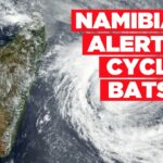
THE Otjozondjupa and Kunene regions should brace themselves as Cyclone Batsirai makes landfall in Madagascar on Saturday, bringing heavy rainfall and strong winds across the SADC region.
This warning was issued by the Ministry of Agriculture, Water and Land Reform.
Heavy storms are most likely in Otjozondjupa and the eastern part of Kunene.
At least 12 people were injured on the French Indian Ocean territory of La Reunion Thursday as Batsirai skirted the island, hitting it with torrential rains and powerful winds and leaving all residents confined to their homes, according to France24.com.
The island was placed on red alert on Wednesday, forcing its 860 000 inhabitants to barricade themselves indoors.
In South Africa, KwaZulu-Natal beaches have been closed in anticipation of the tropical cyclone.
NEWS24 reported the South African Weather Service (Saws) said it is too early to determine how South Africa will be affected by the cyclone. Batsirai passed Mauritius on Wednesday, bringing heavy rain and blasting winds of up to 120 kilometres per hour.
According to Saws chief forecaster Kevin Rae, it seems highly likely that the eastern coastline of Madagascar, particularly the central part of the coast will bear the brunt of strong, damaging winds and torrential rainfall, as Batsirai makes landfall at some stage in the latter half of Saturday, News24 reported.
In other weather news in Namibia, flow was reported in the Fish River due to good rainfall and the dam releases in the Orange-Fish catchment area.
The Fish River recorded 1.24 m at Ai-Ais.
Alertness and close monitoring for possible high floods on the lower part of the Fish River and the Lower Orange remain in place.
The Zambezi River at Katima Mulilo rose to 1.92 m, and the water level is currently above normal.
A decrease in the water level of the Okavango River at Rundu was observed in the past two days, standing at 4.63 m.
Communities are advised to be on high alert and take necessary precautionary measures as more rains are expected.